Tabula Peutingeriana
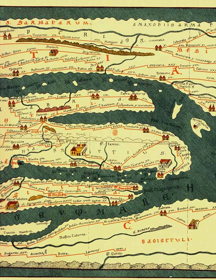
The Tabula Peutingeriana, dating back to the 4th c. AD and also known as the Peutinger Table, stands as a remarkable artifact, serving as an itinerarium—a Roman road map depicting the expansive network of the cursus publicus, the state-managed road system of the Roman Empire.
Believed to be an evolutionary descendant of a map crafted under the supervision of M. Vipsanius Agrippa, a prominent Roman figure, the original map was engraved in marble after Agrippa’s death in 12 BC. Housed in the Porticus Vipsania in Rome, it showcased the intricacies of the Roman roadways. The surviving Tabula Peutingeriana, a parchment scroll created by a monk in Colmar (1265), comprises eleven sections, offering a medieval reproduction of the ancient scroll.

Functioning as a pragmatic overview rather than a geographically precise representation, the map exhibits schematic distortions, especially in the east-west direction. It meticulously illustrates Roman settlements, interconnected roads, rivers, mountains, forests, seas, and even includes distances between these locations. With a staggering 555 cities and 3,500 place names, the map provides a comprehensive insight into the Roman Empire.
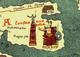
Special decorative icons distinguish the three paramount cities of the Roman Empire—Rome, Constantinople, and Antioch. Remarkably, the Tabula Peutingeriana extends its scope beyond the Roman world, depicting areas in the Near East, India, the Ganges, Sri Lanka (Insula Taprobane), and even offering a glimpse of China. Notably, it features a “Temple to Augustus” at Muziris on the Malabar Coast, a crucial Roman trading port in southwest India.
The western end of the scroll, lacking representation of Morocco, the Iberian Peninsula, and the British Isles, suggests a lost twelfth section, later reconstructed by Konrad Miller in 1898.

Utilizing “itineraries” or lists of destinations along Roman roads, the map reflects the practical needs of travelers, offering a visual guide to the roads’ progression and the distances between vital points. While the parchment’s rectangular layout aligns with convention, there’s speculation about a potential terrestrial representation inspired by Ptolemy’s earth-mapping coordinates.
Hundreds of functional place symbols dot the map, ranging from simplistic depictions of buildings to intricate “portraits” of major cities, encapsulating the essence of ancient Roman road networks and the vital role played by the Tabula Peutingeriana in facilitating travel and trade across the vast empire.


