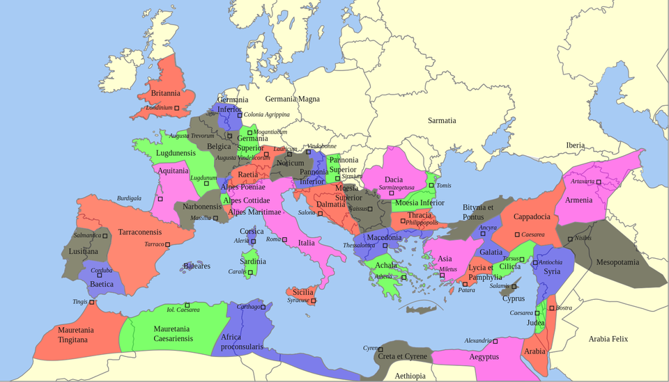
Provinces of the Roman Empire
Embark on a visual exploration of the vast Roman Empire with our meticulously crafted digital map showcasing its individual provinces. This interactive map offers an immersive journey through the various regions that constituted the grand tapestry of the Roman world.

Uncover the diverse landscapes, cultural nuances, and historical significance of each Roman province. From the sun-soaked shores of Hispania to the bustling cities of Asia Minor, our map provides a comprehensive overview of the territorial extent of the Roman Empire.
Zoom in to examine the intricate details of specific provinces or zoom out for a panoramic view of the entire empire. The map is designed to be user-friendly, allowing you to navigate effortlessly through the expansive territories that once fell under Roman rule.
While exploring the provinces, you’ll gain insights into their individual histories, notable cities, and unique contributions to the overall tapestry of the Roman Empire. Whether you’re interested in the agricultural heartlands of North Africa, the strategic importance of Britannia, or the cultural richness of Achaia, our map offers a dynamic and informative experience.
This digital map is not just a visual feast; it’s a gateway to understanding the complexity and grandeur of one of history’s most influential empires. Engage with the map at your own pace, delve into the historical context, and appreciate the geographical diversity that made each Roman province distinct.
This map stands as a testament to the expansive legacy of the Roman Empire, allowing you to virtually traverse its territories and envision the scope of ancient Roman civilization. Immerse yourself in the geography of the past and witness the vastness of the Roman world with our digital map of individual provinces.
