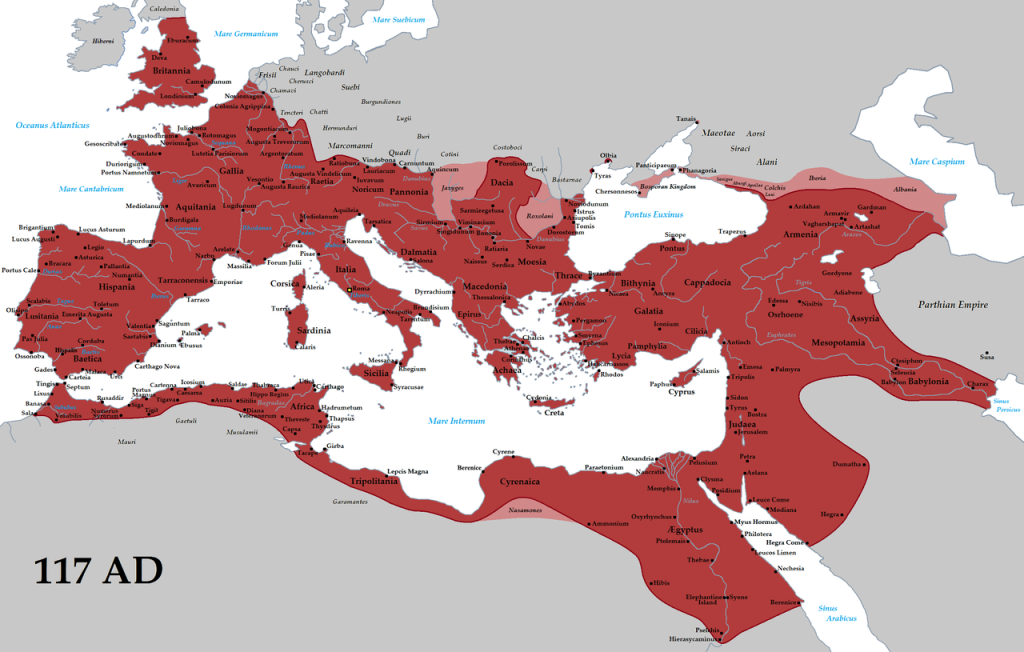
Roman Empire
Embark on a captivating digital journey through the vast expanse of the Roman Empire with our intricately designed map. This interactive experience delves into various aspects of the empire, offering a detailed exploration of its provinces, cities and towns, the mighty Roman army, civic buildings, housing, religious sanctuaries, and the bustling hubs of industry, commerce, and entertainment.

Provinces:
Navigate the sprawling territories of the Roman Empire, from the sun-drenched shores of Hispania to the mysterious landscapes of Britannia. Each province is marked with distinct characteristics, providing a snapshot of its historical significance and cultural influence.
Cities & Towns:
Explore the intricate network of Roman cities and towns, each bearing witness to the empire’s architectural brilliance and urban planning. From the grandeur of Rome itself to the lesser-known gems scattered across the provinces, our map brings these settlements to life with rich historical context.
Roman Army:
Uncover the military might of ancient Rome with a detailed examination of the Roman army. From legionary camps to strategic fortifications, our map highlights the key elements that ensured the empire’s military dominance.
Civic Buildings:
Marvel at the civic structures that defined Roman society. Discover the grandeur of forums, basilicas, and administrative centers that served as the heartbeat of Roman governance.
Housing:
Peer into the daily lives of Roman citizens by exploring various housing structures, from opulent villas to modest apartments. Gain insights into the social fabric of ancient Rome through the layout and design of residential areas.
Religious Buildings:
Step into the sacred spaces of ancient Rome, where temples, shrines, and religious complexes bear witness to the diverse spiritual practices of the empire’s inhabitants.
Industry & Commerce:
Trace the pathways of commerce and industry with a focus on trade routes, markets, and production centers. Witness the economic engine that fueled the empire’s prosperity.
Entertainment Buildings:
Experience the vibrant cultural life of ancient Rome through its entertainment venues. From grand amphitheaters hosting gladiatorial contests to theaters staging classical dramas, our map captures the spirit of Roman leisure.
This digital map transcends traditional visuals, offering an immersive and educational experience that unravels the layers of one of the greatest civilizations in history. Whether you’re a history enthusiast or a student of the past, our comprehensive map provides a dynamic exploration of the Roman Empire’s multifaceted legacy.
