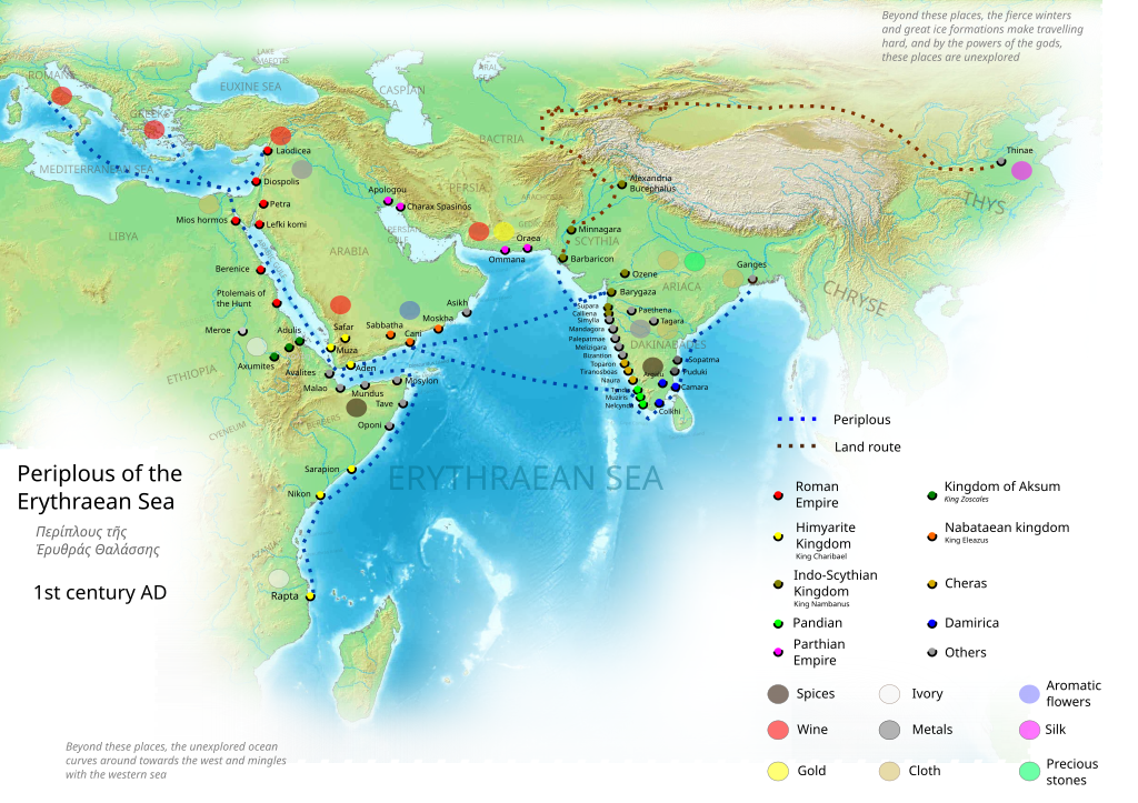
The Periplus of the Erythraean Sea
Embark on a virtual voyage with our meticulously crafted digital map, charting the ancient maritime adventure of the “Periplus of the Erythraean Sea.” This interactive map offers a captivating exploration of the seafaring routes, significant ports, and cultural exchanges detailed in this historical document.

1. Seafaring Routes:
Trace the maritime routes outlined in the “Periplus,” navigating through the Red Sea, Arabian Sea, Indian Ocean, and connecting waterways. Visualize the intricate network of ancient trade routes and the strategic passages explored by seafarers of the time.
2. Major Ports and Trading Hubs:
Explore the major ports and trading hubs highlighted in the “Periplus.” From the bustling markets of ancient cities to the quieter harbors, discover the pivotal locations where goods, ideas, and cultures converged through maritime trade.
3. Cultural Exchanges:
Immerse yourself in the cultural exchanges facilitated by the maritime activities documented in the “Periplus.” Witness the intersections of diverse civilizations, as goods, languages, and customs intermingled along the shores of the Erythraean Sea.
4. Notable Landmarks and Geographical Features:
Delve into the geographical details mentioned in the “Periplus,” including notable landmarks, coastal features, and navigational points. Gain a deeper understanding of how ancient mariners interpreted their surroundings during their voyages.
5. Trade Goods and Commodities:
Experience the trade of precious goods and commodities as described in the “Periplus.” From spices and textiles to exotic treasures, visualize the movement of merchandise across the sea routes and understand the economic significance of each region.
6. Interactive Insights:
Engage with interactive elements that provide additional insights into the historical context, cultural nuances, and the significance of specific locations along the Erythraean Sea. Zoom in to explore details and access supplementary information.
7. Historical Context and Narratives:
Access contextual information and narratives that accompany key points on the map. Uncover the stories of ancient mariners, traders, and the vibrant societies that thrived along the coasts of the Erythraean Sea.
Whether you’re a history enthusiast, student, or someone intrigued by ancient maritime exploration, our digital map of the “Periplus of the Erythraean Sea” offers a visually immersive and educational journey through the seas that connected civilizations in antiquity.
Many thanks to Preston Stone, who did the majority of the hard work on this project and allowed me to share it.
This document is a Greco-Roman periplus written in Koine Greek that describes navigation and trading opportunities from Roman Egyptian ports like Berenice Troglodytica along the coast of the Red Sea, and others along Horn of Africa, the Sindh region of Pakistan, along with southwestern regions of India. The text has been ascribed to different dates between the first and third centuries, but a mid-first century date is now the most commonly accepted. While the author is unknown, it is clearly a firsthand description by someone familiar with the area and is nearly unique in providing accurate insights into what the ancient Hellenic world knew about the lands around the Indian Ocean.

